


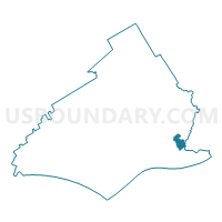
FOLCROFT PCT 02, Delaware County, Pennsylvania
About
Outline

Summary
| Unique Area Identifier | 659329 |
| Name | FOLCROFT PCT 02 |
| County | Delaware County |
| State | Pennsylvania |
| Area (square miles) | 0.99 |
| Land Area (square miles) | 0.85 |
| Water Area (square miles) | 0.14 |
| % of Land Area | 85.47 |
| % of Water Area | 14.53 |
| Latitude of the Internal Point | 39.88911590 |
| Longtitude of the Internal Point | -75.27391750 |
Maps

Graphs
Select a template below for downloading or customizing gragh for FOLCROFT PCT 02, Delaware County, Pennsylvania


Neighbors
Neighoring Voting District (by Name) Neighboring Voting District on the Map
- DARBY TWP WD 01, Delaware County, PA
- DARBY TWP WD 02, Delaware County, PA
- FOLCROFT PCT 01, Delaware County, PA
- FOLCROFT PCT 03, Delaware County, PA
- FOLCROFT PCT 04, Delaware County, PA
- FOLCROFT PCT 05, Delaware County, PA
- GLENOLDEN PCT 03, Delaware County, PA
- GLENOLDEN PCT 04, Delaware County, PA
- PHILADELPHIA WD 40 PCT 38, Philadelphia County, PA
- SHARON HILL PCT 03, Delaware County, PA
- TINICUM TWP WD 05, Delaware County, PA
Top 10 Neighboring County Subdivision (by Population) Neighboring County Subdivision on the Map
- Philadelphia city, Philadelphia County, PA (1,526,006)
- Darby township, Delaware County, PA (9,264)
- Glenolden borough, Delaware County, PA (7,153)
- Folcroft borough, Delaware County, PA (6,606)
- Sharon Hill borough, Delaware County, PA (5,697)
- Tinicum township, Delaware County, PA (4,091)
Top 10 Neighboring Place (by Population) Neighboring Place on the Map
- Philadelphia city, PA (1,526,006)
- Glenolden borough, PA (7,153)
- Folcroft borough, PA (6,606)
- Sharon Hill borough, PA (5,697)
Top 10 Neighboring Unified School District (by Population) Neighboring Unified School District on the Map
- Philadelphia City School District, PA (1,526,006)
- Southeast Delco School District, PA (30,353)
- Interboro School District, PA (23,588)
Top 10 Neighboring State Legislative District Lower Chamber (by Population) Neighboring State Legislative District Lower Chamber on the Map
Top 10 Neighboring State Legislative District Upper Chamber (by Population) Neighboring State Legislative District Upper Chamber on the Map
- State Senate District 1, PA (266,236)
- State Senate District 26, PA (251,041)
- State Senate District 8, PA (243,506)
Top 10 Neighboring 111th Congressional District (by Population) Neighboring 111th Congressional District on the Map
Top 10 Neighboring Census Tract (by Population) Neighboring Census Tract on the Map
- Census Tract 4028, Delaware County, PA (5,697)
- Census Tract 4035.01, Delaware County, PA (4,273)
- Census Tract 4034.02, Delaware County, PA (3,578)
- Census Tract 4029, Delaware County, PA (3,471)
- Census Tract 4034.01, Delaware County, PA (3,028)
- Census Tract 4037.01, Delaware County, PA (1,763)
- Census Tract 54, Philadelphia County, PA (1,314)